Birding Spots in the Okhotsk Region
Here is a short list for now.
Abashiri area
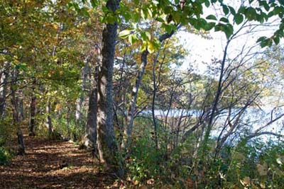 |
| The Yobito Birdwatching Trail in October. |
- Yobito Birdwatching Trail. Yobito is about 10 minutes outside Abashiri on national road 39 heading toward Memanbetsu and Kitami. The entrance to the trail is about 100 meters from the first right turn after you pass Abashiri Lake. If you take a bus, get off at Yougo Gakkou Iriguchi, cross the road, and the road to the trail is the first road before the traffic light. The trail itself is about 7 kilometers along the shore of Abashiri Lake on the Yobito Peninsula. There is a map at the entrance. To come back to where you started, you need to retrace your steps, or you can walk along the dirt road that leads from the other end of the trail. The dirt road goes between fields for about 2 km, and when you see a large school-like facility on your left, you turn left there and walk down the hill back to the national road and the traffic light. This is a beautiful trail. Some more glimpses of it, in early May with a list of birds that were seen at the time, can be found here. (No toilet facilities yet, but there is a parking lot just past the trail entrance on the right.)
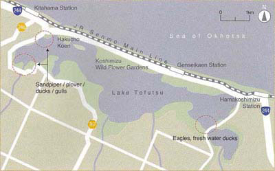 |
| Map of Tofutsu Lake (Source: Tofutsu-ko Waterfowl and Wetland Center Tofutsu-ko Guidebook; Parking areas indicated by "P" have been added.) |
- Swan Park (Hakuchou Kouen). The main spot at Tofutsu Lake for watching shorebirds. You can also drop inside the Tofutsu-ko Waterfowl and Wetland Center that opened in 2012 (open year-round except Mondays) where you will find scopes to use if you like as well as lots of information about the lake. Whooper swans from Siberia winter here and at other areas from late October to late April. Tofutsu Lake became a Ramsar-listed wetland in 2005. (Toilet facilities available at the Center.)
- Heiwa Bridge (Heiwa-bashi). At the east end of Tofutsu Lake. Go further along national road 244 toward Hama-koshimizu, pass the building for the Koshimizu Wild Flower Park on the left, and take the first right after the lake. Go on that road for about 1 km until you come to a bridge (circled in red at right on the map). There are two parking areas there. There are also two parking areas along national road 244 as you pass the lake. They are all good birding spots. The above-mentioned Koshimizu Wild Flower Park (Koshimizu Genseikaen) (open 6 months from May through October) is good, too, but going there in early morning before the crowds come is recommended. (Local information and toilet facilities are available in the building at the park, located near Genseikaen Station.)
- Cape Notoro (Notoro-misaki). About 12 km north of Abashiri. Here you can enjoy extensive views of the Sea of Okhotsk, and on a clear day you will also see the Shiretoko mountain range. During winter, you will see drift ice too when it's in the area. Seals can sometimes be seen here as well as birds. (Toilet facility at parking lot)
 |
- Following the Abashiri River on the south bank from the Michi-no-Eki ("Roadside Station" tourist facility), past the Prison, and around the Ohmagari area, about 5 km. If you don't want to walk the full distance, there are two parking lots, marked P on the map, one near the bridge that crosses to the prison and the other at the bridge in the Ohmagari area, where you can park to make shorter walks. The Michi-no-Eki, by the way, has Abashiri's visitor information center, and a pleasant restaurant upstairs where you can enjoy a tasty, affordable lunch with views over the river to the sea. (The Abashiri Nature Cruise boat during the non-winter seasons and the drift ice sightseeing cruises during winter also leave from here.)
 |
| Aging map of Kinohiroba Reserve at the main entrance. The two red circles I added show locations of picnic tables. (Click map to enlarge.) |
- Kinohiroba Forest Reserve. This is up in the Komaba area of Abashiri. There are several entrances, but the main one is at the end of a residential street, a left turn just after the huge blue and white Aoyama Men's Plaza building across the street from Basic supermarket. This is near Komaba 8-chome bus stop (coming from downtown Abashiri). From the other side of the reserve there are good views over the Sea of Okhotsk and beyond to the mountains of Shiretoko on a clear day. (Small-but-rarely-filled parking lot and toilet available at the main entrance.)
- The above-mentioned Abashiri Nature Cruise is a wonderful way to see seabirds and other marine life on the Sea of Okhotsk from 20 April to 31 October when sailing conditions are favorable. The boat, Chipashiri, that takes groups of up to 20, is small enough to let you see birds and dolphins up close when they are near the boat. The fare is ¥8,800 for a cruise of 2:30 to 3:00 hours. Reservations can be made online (in Japanese for now). (The boat is equipped with a toilet, cabin, and lifejackets.) See the Reports page for links to scenes of excursions taken in the past on this boat.
Further afield
- Wakka Nature Center at the eastern end of Lake Saroma, north of Tokoro, about 1 hour drive from Abashiri. Infrequent bus service is also available. Wakka is mainly open coastal scrubland with a wide variety of birds and wildflowers. The Center building, open late April to late October, provides local information and includes a shop and toilet facilities, as well as bicycles to rent (500 yen) or a horse and buggy if you prefer. A glimpse of Wakka and a bit more information is here, a report of an event there in July 2013.
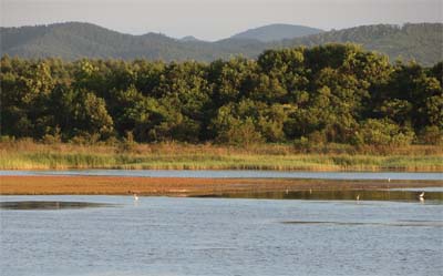 |
| Along the dirt road in the Komuke Lake area |
- Komuke Lake (Komuke-ko). This is a relatively small lake north of Lake Saroma about two hours from Abashiri, but associated waters cover a large area and it will give you plenty of enjoyment and peace while you watch the birds, mostly shorebirds. The turnoff from national road 238 for the road to the lake first takes you to a parking area on the left and the Komuke Lake International Campsite on the right. After that, there is a fork in the road and you veer left to continue on the road, a dirt road, that goes along the the sea side of the lake for several kilometers. Stop anywhere you like along the road. There are ways to get back to the national road by turning left across a bridge, etc. If you veer right at the above-mentioned fork, after a couple of kilometers you will get to Shibunotsunai Lake where the road continues between the sea and the lake. This is worth a detour on your way to Komuke if you have the urge to explore. (Retrace your tracks to the fork when you head to Komuke.)
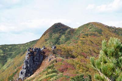 |
| Mt. Mokoto in early October, worth coming to for wildflowers and mushrooms as well as birds and views |
- Mt. Mokoto (Mokoto-yama; 1,000 meters). About 50 minutes drive south from Abashiri, Mt. Mokoto is a very pleasant, easy-to-climb mountain with not only birdlife (abundant with Japanese bush warblers in spring) but also beautiful views over Kussharo Lake and surrounding mountains. The climb is generally 1.5 to 2.0 hours up and 1 hour back. The hardest part is the first 20-30 minutes. The trail starts from the Highland Koshimizu 725 parking lot which you can get to on route 102 that runs between Abashiri (Mokoto) and Kawayu. Adjacent to the parking lot you will find a small shop and café with simple food menu, and toilet facilities in a separate building. Open early May, when the mountain is still covered with snow, to late October. The "official" climbing season starts in mid-June. Another way to climb Mt. Mokoto if you want to get to the top more easily and don't mind sacrificing the views on the way up: take a right from 102 onto a dirt road that starts just before a parking area located on the left (coming from Abashiri). At the corner on the right there is a building. Take the dirt road for a few kilometers and you will first find a shrine on the right, and then about 100 meters after that, a water spring called Ginsei-sui. Leave your car there, refresh yourselves with spring water if you like, and then take the trail through the woods up to the open area at the base of the peak (which you would also come to if you hiked the other way), and continue your climb to the peak. It only takes about 30 minutes from here. (NOTE: Snow might still block your way along the dirt road if you go before the "official" opening; you'll have to turn back in this case. If the road is clear, you will also pass through a fence gate on the way: If the gate is open, pass through as is, but if it is closed, please close it again after passing through, as it is intended to prevent deer from going through. This rule about gates applies wherever you are in Hokkaido. No toilet facilities along this route.)
- Ikushina Wild Flower Park. This is a quiet, mostly natural park east of Shari along the road to Shiretoko. The parking area is big enough for about 10 cars, and from there you can either walk straight ahead for an inland route where you will see mostly inland birds, or you can walk up a short path to the top of a beach route. From the top of the beach route, you will see views of the Sea of Okhotsk and any shorebirds or gulls that might be there. There is very little human activity around this park. (No toilet facilities.)
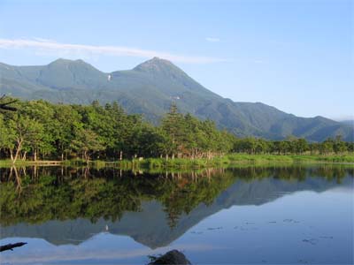 |
| No grebes or swifts can be seen in this photo, but the grandeur of the scene miniscules the humans across the lake. Climbable Mt. Rausu, the highest peak in eastern Hokkaido (1,660 m), is here, too. (5 Aug 2009, DB) |
- Shiretoko Five Lakes (Shiretoko Goko). This is a beautiful area in open nature with both lakes and forest. Shiretoko is now, since 2005, a World Natural Heritage site. The Five Lakes are open to visitors from May to November. While the elevated boardwalk there is freely available to visitors anytime during the season, birders will probably be more interested in the trails around the lakes. If you can't take the trail, at the end of the 800-meter boardwalk is Lake 1 where you might see grebes, or swifts swooping down across the lake's surface. To protect visitors from bears and the ecosystem from visitors, the season for the trails is divided into three periods: the Ecosystem Protection period (up to 10 visitors are allowed onto the trail every 10 minutes and they pay 300 yen for a 10-minute explanation of conditions before entering the trail); the Bear Awareness period (generally mid-May to the end of July when visitors can enter the trail only with a local guide, though bears can still cause tours to be cancelled); and the Free Access period (from late October to around late November). For more details on how to plan a visit to this area, have a look at the Ministry of the Environment site. This is one of several sites you can refer to. The Five Lakes are normally accessed from Utoro, on the north coast of the peninsula; however if you want to come from Rausu on the south coast, you can do so along the highway that crosses the peninsula with beautiful views from Shiretoko Pass along the way (parking available at the pass). The highway is usually open from early May to late October, depending on weather conditions, but if you go in early May, the road might have been plowed but the snow might still be too deep to see any views from your car! (There may be a parking fee at Shiretoko Five Lakes.)
.jpeg) |
| Toward the end of drift ice season. Grey-headed woodpecker nearby. (18 March 2018, DB) |
- Furepé Waterfall (Furepe no Taki). Near the point where the roads to/from Utoro, to/from the Five Lakes, and to/from Rausu and Shiretoko Pass intersect is the entrance to the Shiretoko Nature Center (for local information on trail conditions and bears, equipment, displays, refreshments). Behind the Center is the trail to Furepe Waterfall, about an hour round-trip, partially through woods and partially along a grassland area where you are likely to see deer (to the right out of the photo today). At the end is an observation deck that looks down at the waterfall and out to sea.
- Rausu Lake. Another walk (trek) worth taking through primeval nature and occasional muddy trails is to Rausu Lake, half-day from the entrance at the highway and back, preferrably with a knowledgable guide. There is a bus stop, Rausuko-iriguchi, near the trailhead.
- NOTE: Since bears can scent any food you bring, be sure you have NO FOOD with you when you enter the trails in Shiretoko.
|
|
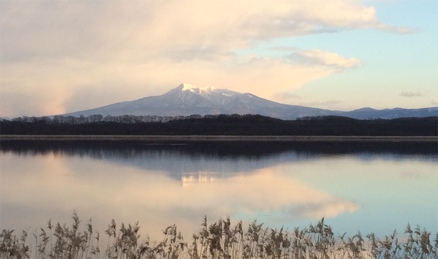
The remains of sunlight at the top of Mt. Shari (from Heiwa Bridge, Tofutsu Lake; 7 December 2013, DB)
|




.jpeg)
